28 August 2013 | Mongabay
Indonesian group vows to map 30 million hectares of customary forest in 7 years
by Diana Parker, Mongabay-Indonesia correspondent
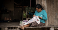
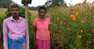
An indigenous peoples’ rights group has vowed to map millions of hectares of customary land in Indonesia, an ambitious target it hopes will help protect indigenous forests from encroachment by palm oil and pulp and paper concessions.
Last May, indigenous peoples in Indonesia won a major victory regarding their rights to customary lands, after a landmark ruling by the country’s Constitutional Court declared state control of customary forests unconstitutional. The ruling theoretically puts 40 million hectares of forest in the hands of indigenous communities. However, over 30 million hectares of customary forests are not yet mapped, leaving communities vulnerable to land grabbing by companies for plantation expansion or other development projects.
“We have already mapped seven million hectares of land, but that took us 15 years,” said Abdon Nababan, the secretary general of the Indigenous Peoples Alliance of the Archipelago (AMAN), a group representing 17 million indigenous people in Indonesia.
“We need to take advantage of new mapping tools like GPS and 3D mapping to accelerate the process of mapping the more than 30 million hectares we have left to document,” he added, speaking at the Global Conference on Participatory Mapping of Indigenous Territories in Sumatra earlier this week.
Abdon said a lack of government support for mapping efforts and the use of outdated technologies has slowed progress. “Based on the mapping technologies we have used so far and the lack of government support for our mapping efforts, it would take us 30 years to map all of the indigenous territories. But we don’t have that luxury,” he said.
While the May ruling was an important symbolic victory for indigenous peoples in Indonesia, the government has yet to announce an implementation strategy. The relatively small percentage of mapped indigenous forests will likely present a serious obstacle to implementing the ruling. Given the urgency the new ruling brings to the forest mapping process, AMAN must learn from indigenous groups in other parts of the world in order to map customary lands more quickly and effectively, Abdan said at the conference, which was attended by indigenous peoples from Nepal, the Philippines, Brazil, Peru, Nicaragua, and Kenya.
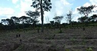
Land conflicts, endemic corruption, and overlapping concessions already plague Indonesia’s forestry sector, and the lack of a unified map of forest areas in Indonesia has been a problem for businesses and communities alike. The government is currently working to create a single map under its one-map policy, which aims to clear up inconsistencies between maps used by different government agencies.
“Some 70 percent of forest areas in Indonesia are located in areas with overlapping permits,” said Kasmita Widodo, the national coordinator of the Participatory Mapping Network (JPKK), an organization that supports indigenous peoples’ mapping efforts. “It will be a challenge for the entire country for us to make the same map so as to facilitate [a] fair decision making process for indigenous peoples and reduce conflicts.”
The participatory mapping conference, held in Samosir, North Sumatra, was organized by AMAN along with Tebtebba, a Phillipines-based indigenous rights organization. The event provided an opportunity for representatives of indigenous groups from various countries to share strategies and discuss ways to ramp up mapping efforts in order to protect customary forests.

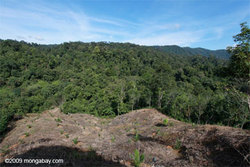
Deforestation in Sumatra (Photo: Rhett A. Butler)
Indonesian group vows to map 30 million hectares of customary forest in 7 years
by Diana Parker, Mongabay-Indonesia correspondent
An indigenous peoples’ rights group has vowed to map millions of hectares of customary land in Indonesia, an ambitious target it hopes will help protect indigenous forests from encroachment by palm oil and pulp and paper concessions.
Last May, indigenous peoples in Indonesia won a major victory regarding their rights to customary lands, after a landmark ruling by the country’s Constitutional Court declared state control of customary forests unconstitutional. The ruling theoretically puts 40 million hectares of forest in the hands of indigenous communities. However, over 30 million hectares of customary forests are not yet mapped, leaving communities vulnerable to land grabbing by companies for plantation expansion or other development projects.
“We have already mapped seven million hectares of land, but that took us 15 years,” said Abdon Nababan, the secretary general of the Indigenous Peoples Alliance of the Archipelago (AMAN), a group representing 17 million indigenous people in Indonesia.
“We need to take advantage of new mapping tools like GPS and 3D mapping to accelerate the process of mapping the more than 30 million hectares we have left to document,” he added, speaking at the Global Conference on Participatory Mapping of Indigenous Territories in Sumatra earlier this week.
Abdon said a lack of government support for mapping efforts and the use of outdated technologies has slowed progress. “Based on the mapping technologies we have used so far and the lack of government support for our mapping efforts, it would take us 30 years to map all of the indigenous territories. But we don’t have that luxury,” he said.
While the May ruling was an important symbolic victory for indigenous peoples in Indonesia, the government has yet to announce an implementation strategy. The relatively small percentage of mapped indigenous forests will likely present a serious obstacle to implementing the ruling. Given the urgency the new ruling brings to the forest mapping process, AMAN must learn from indigenous groups in other parts of the world in order to map customary lands more quickly and effectively, Abdan said at the conference, which was attended by indigenous peoples from Nepal, the Philippines, Brazil, Peru, Nicaragua, and Kenya.
Land conflicts, endemic corruption, and overlapping concessions already plague Indonesia’s forestry sector, and the lack of a unified map of forest areas in Indonesia has been a problem for businesses and communities alike. The government is currently working to create a single map under its one-map policy, which aims to clear up inconsistencies between maps used by different government agencies.
“Some 70 percent of forest areas in Indonesia are located in areas with overlapping permits,” said Kasmita Widodo, the national coordinator of the Participatory Mapping Network (JPKK), an organization that supports indigenous peoples’ mapping efforts. “It will be a challenge for the entire country for us to make the same map so as to facilitate [a] fair decision making process for indigenous peoples and reduce conflicts.”
The participatory mapping conference, held in Samosir, North Sumatra, was organized by AMAN along with Tebtebba, a Phillipines-based indigenous rights organization. The event provided an opportunity for representatives of indigenous groups from various countries to share strategies and discuss ways to ramp up mapping efforts in order to protect customary forests.