Land grabbing: what is it?
Land grabbing is a term that describes the acquisition of farmland by companies, governments and individuals. In the last years the term has been used to refer to the large-scale acquisition of farmland by foreign investors, a trend that has increased since the 2007-2008 world food price crisis, which prompted a renewed interest in foreign lands as a means to achieve food security and as a financial investment. The governments, agribusinesses and investors that have bought or leased these lands are using them for the cultivation of food crops that are then exported and for the production of cash crops and biofuels.
It has been argued that land-grabbing displaces local communities and small-farmers to replace them with large scale agriculture and that this will ultimately increase, instead of diminishing, food insecurity in the 'global south', deteriorate the environment and cause livelihood and biodiversity loss (Source).
Cartogram: what is it?
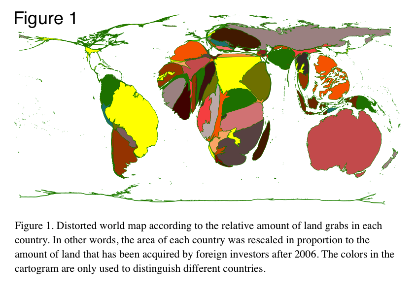
An area-cartogram is a map where each geographic area has been scaled (distorted) proportionally to the size of an attribute or variable. In this case each country’s area has been scaled in proportion to the amount of land that has been acquired by foreign investors since 2007 (dataset from Grain). In other words, the area of countries where more land was grabbed will be inflated and the area of countries where less land or no land was acquired will be shrunken in comparison to the normal world map.
Methods: how was the cartogram generated?
I used a dataset of land-grabs released by Grain to compute the cartogram with the free software ScapeToad. The following were the main steps:
- I aggregated the data by country (total area of land-grabs in each country)
- I used the aggregate dataset to create an attribute for land grabbing in a world map in ESRI shapefile format
- I used the world map shapefile with the attribute for land grabbing to generate a cartogram with the free software ScapeToad
- I colored the map with the free software Inkscape


