Customary land map, a first for Indonesia, launches to mixed reception
by Hans Nicholas Jong
-
Indonesia has published its first ever map of customary forests, in a move it says is aimed at demarcating indigenous lands to prevent land grabs by businesses and developers and resolve existing conflicts.
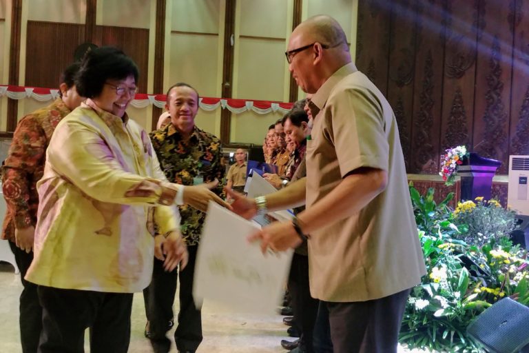
 Indonesian Environment and Forestry Minister Siti Nurbaya Bakar handed over the indicative map of customary forests during the launching of the map in Jakarta. Photo: Hans Nicholas Jong/Mongabay.
 - The government says it expects the publication of the map to help speed up the process of legal recognition of indigenous communities, which in turn is needed to establish their land rights.
- But indigenous rights activists are unconvinced, saying the land recognition process for local communities continues to be hampered by onerous bureaucratic requirements.
- They’ve called on the president to issue an executive order that would abolish those requirements and speed up the process of legal recognition for indigenous communities and their land rights.
JAKARTA — The Indonesian government has launched an official map of customary forests, the first of its kind in the country, in a bid to protect them from land grabs.
The map identifies more than 4,700 square kilometers (1,800 square miles) of untitled land as constituting customary forests, or hutan adat, defined as those occupied or claimed by indigenous communities. By mapping these areas, the government can earmark them for its social forestry program, which would award formal title over the land — in perpetuity — to the indigenous and local communities that have long occupied them. Failing to map them, said Environment and Forestry Minister Siti Nurbaya Bakar, would leave these areas open to competing claims from businesses and developers.
“We need to record these indicative locations because once they’re on the map, they won’t be used for other purposes and [development permits] requested by anyone,” Siti told reporters at the launch of the map in Jakarta.
The map is expected to help address conflicts over land simmering across the country, most of them fueled by the fact that no legal titles exist for much of the community-occupied land in Indonesia, leaving them up for grabs to agribusiness, miners and loggers.
When the land rights of indigenous communities aren’t recognized by the state, they’re left without any legal protection against land grabs by big businesses, Siti said.
At least 152 indigenous communities were mired in land conflicts as of the end of 2018, with 262 community members facing criminal investigation as a result of their fighting back, according to the Indigenous Peoples Alliance of the Archipelago (AMAN), a leading advocacy group that counts more than 2,300 indigenous communities as its members.
Safeguarding these customary forests will help prevent future conflicts and resolve ongoing ones, Siti said.
“We can see that the social forestry program in general, including customary forests, have been able to ease conflicts,” she said. “That’s why even if the customary forests [in the new map] are just indicative at this moment, it’s better to map them anyway in order to block out other interests that could potentially lead to conflicts.”
The map will be revised once every three months, with the aim of increasing the mapped area of customary lands. The end goal, Siti said, is for the government and private companies to relinquish control over all of the earmarked areas to the indigenous and local peoples whose presence there predates their arrival.
Bambang Supriyanto, the head of social forestry at the environment ministry, said the government aimed to have some parts of the mapped customary forests legally recognized by the end of this year. He said the ministry would first work on squaring away those areas seen as quick wins — indigenous territories for which the communities already have the necessary legal documents and only need to be verified and approved by the ministry. These constitute about 330 square kilometers (127 square miles) of customary land.
“If we can finish [the legal recognition] in the next three months, then there will certainly be more customary forests recognized in the second phase,” Bambang said.
Slow progress on legal recognition
The publication of the map marks the latest step toward full recognition of indigenous rights since a milestone court ruling in 2013 that rescinded state control over customary lands and gave it back to the community.
The progress since then has been piecemeal, however, with the process of legal recognition hampered by the government’s notorious bureaucracy.
In the case of formal state recognition of customary forests, for instance, the community applying for the title must first gain recognition of its status as an indigenous community.
This, in turn, can only be conferred through the issuance of a local executive decree or bylaw.
Siti said this new map should go some way toward easing that process, by giving local district chiefs and district councils a basis for issuing those decrees or bylaws.
“With the map, we hope local governments can soon take real action in accordance with their authorities as stipulated by the law, in this case to formally recognize indigenous peoples in their respective regions,” she said.
Others aren’t as convinced. R. Yando Zakaria, founder of the Ethnographic Study Center for the Rights of Indigenous Peoples (PUSTAKA), said indigenous communities would still face an uphill battle in getting their customary rights recognized, given how tedious and time-consuming the process of winning legal recognition from local councils and politicians can be.
For a bylaw to be issued, indigenous communities need to lobby their local council to draft and legislate such a bylaw — a costly process that can take years. It took one community five years to secure such a bylaw in place; in areas where local governments have already granted concessions on the land, it can take even longer, if at all.
“If we look at the reality on the ground, [the map] is woefully insufficient,” Yando told reporters. “For a bylaw to be issued, it can take up to two years. And the minimal cost is 200 million rupiah [$14,000]. That means the legal framework actually hinders the [process of legal] recognition, and that’s an unfair policy.”
The process, which typically involves the drafting of technical reports and legal documents, is also highly reliant on outside support from NGOs. For their part, local councilors and district chiefs tend to be reluctant to support bylaws that don’t offer them an immediate political or electoral advantage.
“Can you imagine [indigenous] peoples, who don’t have the political capacity to draft a bylaw, being forced to do so?” Yando said. “If there weren’t any NGOs [helping them], how could the process proceed? How long must we rest the fate of indigenous peoples on NGOs? NGOs can operate because they have donors, so how long do we want to have to depend on these donors?”
All these factors have combined to make Indonesia’s progress toward official recognition of its myriad indigenous communities a slow process. As of April this year, the environment ministry has granted titles to just 49 communities for a total of 222 square kilometers (77 square miles) of land under the customary forest scheme — far short of the 58,000 square kilometers (22,400 square miles) of customary forests that the government has set itself the target of titling by the end of this year.
That target, in turn, is just a fraction of the 400,000 square kilometers (154,400 square miles) of land, or 30 percent of Indonesia’s total forest area, that Indonesia’s indigenous groups historically occupied, according to AMAN.
Participatory mapping
Help to speed up the land rights recognition process has come from outside the government, with a group of NGOs banding together to guide communities through a process of participatory mapping. The Ancestral Domain Registration Agency (BRWA) established by these NGOs brings together the results of each mapping process, and to date demarcates about 96,500 square kilometers (37,300 square miles) of indigenous territory — an area 20 times bigger than what the environment ministry’s new map identifies.
Bambang, the ministry official, said he had assessed a copy of the participatory map and found a large chunk of it administratively incomplete; only 36,600 square kilometers (14,100 square miles) of the mapped area had local bylaws or decrees issued for them, he said. Of that, about 30,000 square kilometers (11,600 square miles) lacked clear identification of the indigenous communities laying claim to them and thus needed additional documentation.
“That’s why we can only determine indicative locations [of customary forests] for 4,729 square kilometers of land,” Bambang said.
He added that his office would instruct local authorities to accelerate the issuance of bylaws, decrees and other necessary paperwork to complete the processes.
Indigenous rights legislation
Proponents of indigenous rights have been actively campaigning for the government and lawmakers to issue a specific law on the rights of indigenous peoples as one of the ways to speed up the legal recognition of customary lands.
Parliament is currently deliberating a bill on the matter, which has been hailed as a much-needed step toward enshrining protection of indigenous rights in the country’s laws but which has been stuck in legislative limbo for years as relevant ministries haven’t submitted letters with a list of recommendations and inputs to parliament. Parliament needs the letters in order to proceed with its deliberations of the bill.
Yando said the passage of the bill could take a long time, if it passes at all.
“My friends want to change the existing legal framework with the bill, but the political process isn’t easy,” he said. “With that in mind, if the government is serious about its commitment [to recognize customary lands], then we need to report to the president that he needs to issue an executive order to solve this problem.”
Such an order, Yando proposed, would override the onerous existing requirement for indigenous communities to obtain a local bylaw or decree to be legally recognized.
“That stipulation is there as a remnant of the New Order regime,” he said, referring to Indonesia’s military-led pre-democratic regime that ended in 1998. “[It’s] aimed at enabling the government to control as vast an area of forest as possible. That’s why if the government and the president are serious about indigenous peoples, they have to do that” — revoke the requirement.
Should that happen, indigenous communities will be spared the arduous political process of lobbying their local councils and district chiefs.
“Why should the existence of indigenous peoples, whom we can see with our own eyes, be debated inside the halls of local councils?” Yando said. “It’s easier to get a plantation business permit than customary forest recognition, because for a plantation permit you don’t need to go to the local council.”
He said it would be easy for the administration to justify issuing an executive order, given the long history of indigenous communities across Indonesia being denied their rights.
“We have a precedent, when the mining industry entered forest areas and the government issued an executive order [in 2004] to make it legal for mines to operate inside protected forest areas,” Yando said. “So why can’t the government issue a regulation for the sake of indigenous peoples?”